As Landcarers we want to understand the features of the properties that we work on. This can be as Landcare Groups or individuals with a farm or small block of land that is our rural escape location. In the a series of articles, we will attempt to gain and understanding of “our patch” by using a range of sources that are now available to us through internet access.


A good place to start in our understanding is to visit Sixmaps, a website provided by the NSW Government that allows the identification of property boundaries and Lot numbers.

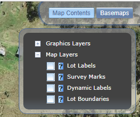
Find your location on the map of NSW (It looks like a Google Map which we will discuss another day.) You will need to identify what information you require in the box on the screen and then it will overlay that information on the map. (Sometimes the layering takes time so be patient). The Lot labels only appear at a higher magnification.

You will then be able to compare the information with the cadastral maps you have of your property to see that they agree. You can also verify the area of the lot and the length of the perimeter by using the appropriate items in the tool bar.
With the property boundaries established it is then possible to begin constructing a collage of information about the property so this can be layered commencing with the geology of the area through soils to vegetation and current use observing other features along the way.
Happy investigating!

